Made by the self-described hacker, trainspotter and map addict Vasile Coțovanu, the interactive rail map uses data from the federal railway organisation SSB to show the movement of trains across the country in real time. If you’re too impatient to watch the trains crawl across the map, you can speed the whole thing up. If you feel the need to follow a particular train, you can do that, too.

The map is not actually live, as such: it uses timetable data to show where trains are meant to be, so doesn’t show delays and so forth. But Swiss trains have such a reputation for punctuality that the joke is the locals set their watches to the trains – so we can be fairly sure what we’re seeing is spot on.
The map also, indirectly, shows both the physical and human geography of the country. You’d be hard-pressed to find a more iconic duo than Switzerland and mountains: the country’s topography has allowed the small republic to keep out of Europe’s wars for centuries.
But as well as providing a natural barrier that would make Donald Trump go green with envy, the mountains have been a huge obstacle for the engineers tasked with building the country’s rail system.
Interactive rail map
This map shows the rail network in its entirety: note the concentration of red to the north, representing the Swiss Plateau. Hemmed in to the north by the Jura Mountains and to the south by the mighty Alps, this stretch of relatively flat land was an obvious choice for settlers, and although it only covers 30% of the country, two-thirds of the total population lives there.
In the rest of the country, though, rail coverage really thins out. Tunnels and difficult spiral climbs are necessary for trains taking on the mountainous south.
Despite its difficulty, the route through the Alps along the Gotthard Pass has been an important trade route for centuries. It is the shortest route between the Po and Rhine Rivers, and control of it has been a key objective for the Swiss state.
Seven years ago a new rail line opened along this north-south route, known as the Gotthard Base Tunnel (GBT). The tunnel can be seen in the more faded red, running from Erstfeld to Biasca:
It’s the longest and deepest rail tunnel in the world running for 57km under the Alps. At its deepest point, the GBT is 2,450m deep. This incredible feat of engineering allows faster and more frequent journeys through the mountains and onto Italy.
The Alps aren’t just an obstruction, though: where railway lines have managed to wind their way through you can find some of the most beautiful train journeys in the world.
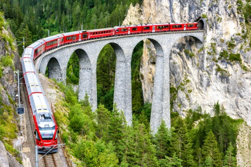
The Bernina Express is the sort of old-school Alpine train where you imagine you could find James Bond in the bar carriage. It travels along two World Heritage railways, the Albula and the Bernina, which are among only a handful of rail lines whose importance has been recognised by Unesco. Sweeping past glaciers and lakes, the train goes through 55 tunnels and across a mind-boggling 196 viaducts and bridges.
[Read more: What is Europe’s longest train journey?]


