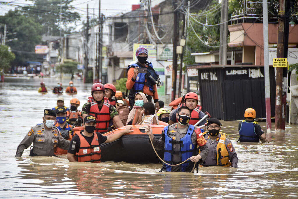
Jakarta is polluted, overcrowded and sinking, due to the ever-worsening floods. A $35bn plan, which should be completed by 2024, will relocate its capital city and civil servants to Nusantara (an Old Javanese term meaning “outer islands”), 1,300km away in the East Kalimantan province of Borneo.

The founders of Jakarta did not imagine the city this way. From its early existence since Indonesia’s independence in 1949, it was meant to be a modern, financial hub and an engine in the country’s push into the international economy. Locals and visitors are reminded of this every day as they pass by the Welcome Statue in the Hotel Indonesia roundabout.
This site has also become somewhat prescient of Jakarta’s fortunes against the savagery of climate change. Daily commuters to Jakarta have reached one million people. Economic losses from traffic jams range from $4.5bn to $7bn. Jakarta is an example of a sick city, in need of drastic measures. The new capital, on the other hand, aspires to be a model of human co-existence with the environment.
[Read more: What can a megacity like Jakarta do to tackle pollution and end gridlock?]
Many alternate sites were considered, including Palangkaraya and several ones on Java Island. Marked at the geographic centre of Indonesia and linking the North Penajam Paser and Kutai Kartanegara Regencies, Nusantara hopes to be a “Forest City” – a “new high-tech, smart city, surrounded by forest”.
This poses challenges in a country of contradictions, many of which are environment-related. Indonesia has the world’s fourth-largest population, although 9.7% are living in poverty. The price tag for relocation is expected to be exorbitant; a 99km stretch of road running along Nusantara alone is estimated to cost $767m.
Its people, furthermore, are voraciously depleting its natural resources and destroying the remaining safeguards against extreme climate events. Although Indonesia is a founding member of the F-11 coalition of forested countries, its domestic companies regularly cut down trees to fuel economic growth, leaving others the task of monitoring the depletion of this great carbon sink.
The design for the new capital, entitled “Forest Archipelago”, will feature green space tagged by an array of landmark plazas and connected by a smart mass-transit network. But the carbon footprint of clearing the forest for construction will be great – for example, experts calculated that 48 million tonnes of carbon dioxide will be released into the atmosphere.
Ironically, despite its huge archipelago, Indonesia often needs to think and plan like a small island country as rising sea level threatens its coasts. The urgency of Jakarta’s struggle can be best felt by this factoid: the city has been sinking 25cm annually in certain areas.
The extent of flood damages
What is the culprit of Jakarta’s troubles? Most would say flooding. In 2019, 40% of the city was below sea level. Amsterdam, by contrast, is one-third below sea level. Patrick Daly and Paolo Testolini, architects at London-based Woods Bagot, called it the “region’s most vulnerable city to climate disasters such as flooding”. A study by the government predicted that the Soekarno-Hatta International Airport may one day be permanently flooded.
Mark Caljouw and Peter JM Nas gave an account of an extreme climate event in February 2002. Torrential rainfall submerged three-quarters of the city and knocked out electricity. Most of the flights coming into Jakarta were cancelled. But the government initially refused to elevate the emergency status to its highest level. In normal storms, the floodgates to the Inner City Ciliwung River, which runs to the presidential palace and several commercial districts, are closed – and guarded by soldiers – and water is diverted through the West Banjir Canal to West Jakarta. Ultimately, both floodgates were opened and many popular landmarks were inundated.
Daly and Testolini speculated on the causes of the flooding. Underneath Jakarta are underground aquifers that store the abundant rainwater seeping through the ground. To the north of the city is a district through which numerous canals have been built and are subsequently flooded by water that cannot flow into the aquifers. Ill-advised land development that favoured “hardscaping” over natural vegetation exacerbated this trend.
The city has only one-third of the optimal amount of green space for naturally draining heavy rainfall. Kota, the ground-zero of this process of abuse, is sinking at “three-to-four inches per year” and is already being de-populated. Added to this are other human-made factors like sediments from deforestation, garbage build-up, and unapproved structures like squatters’ huts, which narrow the waterway and create backwater as water tries to flow into the Java Sea.
Triarko Nurlambang, of the University of Indonesia, argued that a human security approach should be used to look at flooding, rising seawater, twisters, and landslides and their impact: they are “serious and potentially harmful hazards for the most marginal people living in the city’s coastal areas.” In fact, the number of villages in Greater Jakarta that have succumbed to flooding annually is in the double digits. Floods and natural disasters bring not only economic losses but also diseases that induce a vicious cycle for the poor.
Rita Padawangi and Mike Douglass of the National University of Singapore reported that while 40% of the residents in Kampung Pulo have a water supply, it could not be used for drinking after a flood because of the poor quality. After the 2002 flood, there were widespread cases of diarrhoea, flu and skin diseases. According to Mari’i Mohamad, of Red Cross Indonesia, the poor “did not have the money to buy new beds or to repair their houses”. Some 68.4% of residents with flood-damaged homes had to sell. The poor could neither afford to do this nor implement anti-flood measures, like raising the floor of one’s house.


